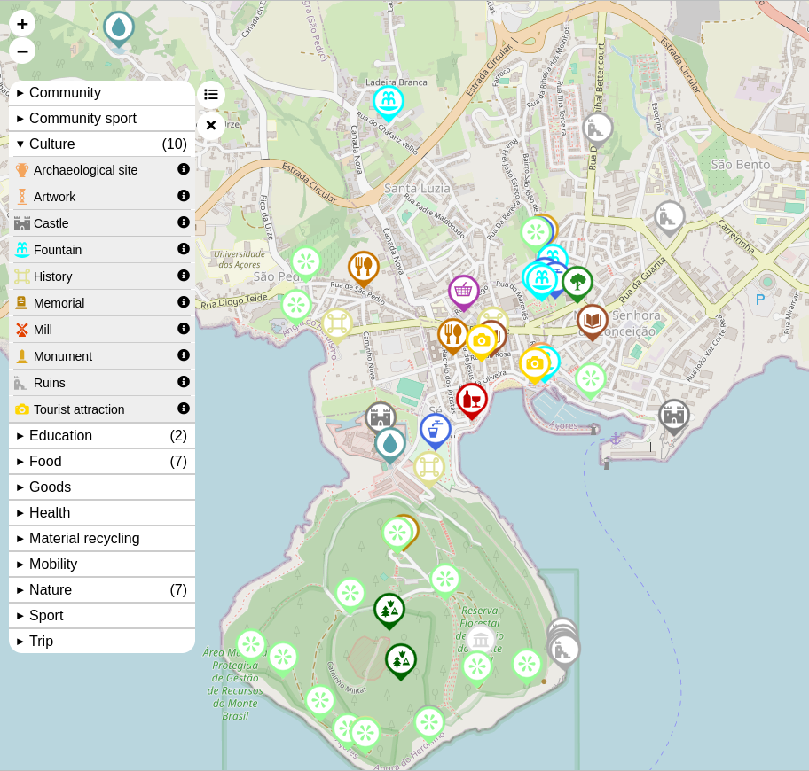
Sustainable Map [] | © sustainable.zottelig | map data © OpenStreetMap contributors
Mapping campaigns
- contrapunctus has suggested hosting a mapping party to coincide with DebConf24, which will be held from 28 July to 4 August at Pukyong National University, Busan, South Korea. Hwang Dongha said that attracting the local OSM community, Debian user groups, and Ubuntu user groups to the mapping party would be an easy way to get people together, and would also create an opportunity to promote OSM in South Korea.
Community
- In response to the recent OSM vandalism controversy, caused by some players of Niantic’s Pokemon GO, Ilya Zverev has written a short essay titled ‘Не вина Niantic‘ (It’s not Niantic’s fault), justifying Niantic’s move to join Overture Maps rather than the OpenStreetMap Foundation.
- Jiří Eischmann, a Red Hat desktop engineering manager among other things, made the following recommendation on Mastodon: ‘If you’re exploring OpenStreetMap like me and [you find] openstreetmap.org is too heavy for you, try OSMapp…’, a statement that triggered a few comments.
- … elsewhere, Jiří Eischmann also commented on OsmAnd and mapycz. David Heidelberg, a Czech Linux developer, suspects that Jiří has fallen in love with OSM.
- Julien Coupey shared his favorite OSM note of the moment (or possibly the year) : ‘Note 4097195 : The former sex shop has become a “evangelical protestant church”. I’m announcing I’m not touching that’.
- Maurizio Napolitano presented a webinar entitled ‘OpenStreetMap: A collaborative Ecosystem Serving Society and Business’. The webinar discussed the role of OSM in enhancing innovation in the public and private sectors.
- Kamil Monicz has published his OpenStreetMap NextGen Development Diary #5.5. At the end of May, OpenStreetMap-NG will include the necessary functionality to run on a testing server, as well as to invite new contributors into the project.
- The UN Mapper of the month for May is Modo Levo Engelbert Steve, a geomatics student from Cameroon.
- Brian Sperlongano has conducted a statistical analysis of the distribution of the populations of places in OpenStreetMap.
Events
- Pieter Vander Vennet announced that he will be holding an OpenStreetMap workshop for beginners in Ghent, Belgium on Thursday 16 May.
Education
- As a special guest, Dr Raquel Dezidério Souto gave a workshop on the creation of web maps with uMap and OSM data for a class at the Centro de Investigaciones en Geografía Ambiental, at the Universidad Nacional Autónoma de México. This was part of the PACES course coordinated by Professor Michael McCall. She described her expeience in her diary and shared the link to the recorded video for those who want to create a map like this.
- The Trufi Association drew attention to its free ‘Public Transport‘ online courses.
OSM research
- A study published in Geo-spatial Information Science analysed how the provision of OpenAerialMap images is associated with changes in the underlying editing patterns of OSM features.
Maps
- [1] MapAmore reviewed ‘Sustainable Map‘, an OpenStreetMap-based web map that focuses on environmental sustainability themes.
OSM in action
- Tykayn used MarineTraffic, a website displaying global marine traffic using OpenStreetMap data, to ponder how many people are currently at sea.
Open Data
- As part of their migration process to Overture Maps, Meta has decided to discontinue the Daylight Map Distribution, a dataset derived from OpenStreetMap data, first released in March 2020. The last release is scheduled for November 2024.
- Shizuoka Prefecture is known as an innovative region of Japan. In an article on the prefecture’s website they explained the ‘VIRTUAL SHIZUOKA concept’ (an open point cloud database available under CC BY 4.0). This enables Shizuoka Prefecture to be captured and experienced virtually.
Software
- Ilya Zverev has released Every Door version 5.0. Now, you can try the freehand line drawing mode to sketch streams, culverts, walls, fences, cycleways, power lines, footways, paths, roads, and tracks by using the fourth mode for notes.
- TrickyFoxy has developed a Tampermonkey script to add some functionality to the OpenStreetMap website.
- Jeyseni recommended using OsmAnd as it is reliable enough to be used as an offline map application in Japan.
OSM in the media
- Jomo noted that Germany’s most prominent TV news show, the Tagesschau (Review of the Day), is using OpenStreetMap and Maptiler to render maps in their brand design.
- Tama Plaza News, a local news site covering the suburbs of Tokyo, Japan, recommended OpenStreetMap as a site for looking up street names.
Other “geo” things
- Grant Slater is annoyed with Wikipedia, which rejected his attempt at creating a new article for a large dam, as it was not deemed notable enough.
- OpenCage explained the annotation feature in its geocoding API. This feature serves to provide various additional information about a location.
- OpenCage shared a news story about the local residents protesting as a result of the policy of the North Yorkshire council that is forcibly removing apostrophes from the local addressing system, allegedly due to the computer security risk they may pose.
- Rakushouke, a keen Pokémon GO trainer, embarked on a short trip to Lake Biwa, Japan’s largest freshwater lake, located near Kyoto. With the help of OpenStreetMap, they successfully tracked down Wiglett (ウミディグダ/Umidigda in Japanese) and documented their findings in a photo blog .
Note:
If you like to see your event here, please put it into the OSM calendar. Only data which is there, will appear in weeklyOSM.
This weeklyOSM was produced by SeverinGeo, Strubbl, TheSwavu, TrickyFoxy, YoViajo, adiatmad, barefootstache, derFred, euroPathfinder, miurahr, rtnf.
We welcome link suggestions for the next issue via this form and look forward to your contributions.